|
| Low Fog kisses the Highlands along the Cabot Trail |
Place yourself for
a moment in the office of a tuna tagging scientist staring at a map with a GPS
location of a popped-off mini-PAT satellite tag.
The tag had been attached to a Giant Bluefin Tuna for the past 10
months, and it contains a virtual diary of its movements, behaviours and
environments encountered. The tag is
sending a summary of the tuna’s story to a satellite which relays it to your
computer. This summary data is like
reading the first and final chapter of a novel and the story line on the back
cover. It’s valuable and you get the
highlights and main point of it all, but you feel cheated somehow, especially
after you spent weeks travelling and fishing to tag the tuna in the first
place. If you can get the tag back, you can download the entire "story".
A lot of tags pop
off far from shore, well beyond reach of an inshore vessel’s range. So what happens when a tag comes to the
surface 15 kms from shore? And 25 kms
from the nearest port where you know a local fisher who has a boat at the
dock? You scramble; you email, call and
coordinate a recovery as fast as humanly possible…and then you pray, for good
weather, calm seas and good visibility.
On Wednesday, this week, such an event happened. Although I wasn’t the scientist staring at
the map of the first GPS location, early Thursday morning...I was the scientist
along with a Honours student from Acadia University rushing to the dock to jump
on board the ‘Mary Heather’ captained
by TAG-A-GIANT’s Captain Lloyd MacInnes based out of Little River, Cape Breton,
Nova Scotia.
 |
| The search for the tag begins |
Finding a tag the
size of an egg with a thin black antenna sticking out would be an ok Easter-egg-hunt on land. However, throw in waves, a large area, a GPS location that is
hours old, and the fact that the tag is floating with only the antenna peaking out, all of a sudden the easter egg hunt isn't quite as easy. That’s where Seth Newall, a Honours student
from Acadia University comes in. He
brought a "tag locator" with him, which picks up the specific frequency of the tag
and allows us to home in on the signal.
It’s a lot like playing ‘hot-cold’ as a kid, except you’re still looking for a black, half-submerged tag within 300 to 50 m of the boat. So
with Captain Lloyd at the helm spinning circles and squiggles on his chart
display, Seth relaying signal strength of the tag, and myself standing on the
cabin roof searching the water, we played that very game. It was bit foggy, but relatively calm, no
breaking waves or chop. With help texts
coming from TAG-A-GIANT’s Robbie Schallert in Texas, we honed our rookie skills
using the tag locator. Seth’s signal
strength got stronger as the search continued.
After 3 hours of playing hide-and-seek, I spotted the black egg with antenna
sticking straight up, 20 m off the port bow.
“I got it!” I
yelled out, “10 o’clock! 60 feet off the port side!”
“I see it!”
confirmed Captain Lloyd.
“Seth, grab the
dip net while I keep an eye on it!” I instructed.
Captain Lloyd had the boat alongside the tag
within seconds. He wasn’t waiting for a
dip net. He had a deck-brush in hand and
was frantically sweeping the tag closer to the boat. Seth netted our find and with that, we had in
hand the day-to-day story of one Bluefin.
 |
| Relieved Capt. with the tag |
 |
| Close up of the Wildlife Computers miniPAT |
Steaming back to
port, the sun broke through the fog to illuminate the sea’s surface and rocky
cliffs onshore, yet the lush green mountain tops of Cape Breton’s Highlands
remained covered. A pod of white-sided
dolphins broke the surface and a puffin dove under upon the Mary Heather’s approach. Some gifts in view while others remained out
of sight, a fitting summary to our search’s conclusion.
 |
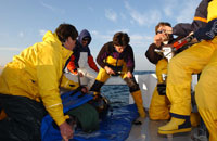
| Acadia Team with the tag safely secured!! |
-
Written by Aaron Spares, Acadia
University Coastal Ecology Lab