Friday, October 4, 2013

Canada 2013: Epic Tagging


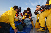
Dr. Steve Wilson and Robbie Schallert tag a giant bluefin
in Port Hood, Nova Scotia

The TAG team is up in Canada where we’ve had an epic 5 days of nonstop bluefin tagging.  I’m Ethan Estess from the Monterey Bay Aquarium and Stanford University’s Tuna Research and Conservation Center, here with TAG scientists Robbie Schallert and Dr. Steve Wilson of Stanford University. We came to Port Hood, Nova Scotia on September 27th to work with Mike Stokesbury’s team from Acadia University to study giant bluefin in the Gulf of Saint Lawrence. 

TAG team Dr. Steve Wilson, Robbie Schallert (center), and Cpt. Dennis Cameron (at head irrigating the gills)

We awoke on the 28th to flat calm seas and sunny skies. The Tag-A-Giant team headed out with Captain Dennis Cameron and Craig of the Bay Queen IV and Bernie and Steve of the Carrie Anne.  The bait had barely hit the water when we hooked up on a giant bluefin tuna.  An hour later the 270cm fish was on the tagging mat and a minute later it was back out the door, outfitted with an acoustic and pop-up archival tag (PAT).  These tags will help unlock the mysteries of bluefin migratory patterns and spawning cycles, providing critical information for their management and conservation.   To date most of these Canadian giants have been tracked to the Gulf of Mexico spawning grounds, but a few (less then 2%) make their way to the Mediterranean Sea.

A giant bluefin being reeled in by the crew of the Bay Queen IV

The bluefin were there in force to feed on the large schools of herring in the region.  We double tagged 6 fish with acoustics and pop-ups, and many of these fish were the largest I've seen.  All of Sunday’s fish were over 260cm, easily weighing 800 pounds or more.  These fish were extremely well fed and very big around!

Measuring the length of a giant bluefin

Over the next 3 days we deployed 14 more electronic tags in perfect fishing conditions.  Cape Breton is one of the most beautiful places I’ve ever been and we were surrounded by spectacular wildlife.  Hundreds of pilot whales, or “blackfish” as our captain called them, circled our boat throughout.  They were there for the same reason the bluefin were- to feed on the massive schools of herring spawning along the island.   Gannets dive-bombed and grey seals bobbed along with curious glances towards our bait.  One of the highlights of the trip was placing a tag in the largest giant bluefin TAG has ever tagged- a 313cm bluefin we tagged and released.  This behemoth barely fit on the deck of the Day Queen IV.  This fish is surely a spawner, and hopefully its PAT tag will teach us about bluefin spawning locations and behaviors in the Gulf of Mexico.

Surrounded by hungry pilot whales with our other fishing vessel
the Carrie Anne in the background

Cape Breton sunset

Friday, July 5, 2013

Eagle Eye and Homing Pigeon

Background: 

On September 23rd and 24th, 2012...TAG Canada deployed two miniPATs on bluefin tuna 270cm and 283 cm respectively. On July 1st, they popped off in separate locations...one off the East Coast of the US and the other off the west coast of Cape Breton. And so the hunt for the satellite tag began...you see if our scientists are able to recover the tag, we can download the entire archival record of the tag,  ie. we get more information about where the fish have traveled. But, imagine trying to spot a small float with an antenna sticking up in the open ocean...even on a flat calm day it is virtually impossible. So we deployed our best scout team, Dennis "Eagle Eye" Cameron and Jeff "Homing Pigeon" Beardsall, to try and find the proverbial needle in a hay stack.
Here is a picture of the 283cm fish right before it was tagged on Sept. 24th.
From Jeff Beardsall (who was in the field looking for the tag in Nova Scotia):

My initial reaction to the whole hunt was how cooperative the weather was, and the very nice timing of the whole thing. For about 4 or 5 days prior to the tag releasing the weather had been terrible (rain and wind), so had the tag released earlier we would have had to sit and watch it float out to sea. On top of the weather Dennis had mentioned the boat was out of service for some quick repairs, and the refueling kept him on shore until the moment he left. On his steam up the coast to Pleasant Bay the wind and waves were up and he was thinking that the weather was going to be a huge obstacle in spotting the tag.

Meanwhile I'm tearing across the province in a classic adventure vehicle (1997 Jeep Cherokee) on roads that haven't been resurfaced in about 20 years (my best guess) with urgency after getting off the phone with Steve who had mentioned the tag was taking a line for the Cabot Strait, and once something gets caught in that tide current it moves easterly fast into open ocean. So in my mind it was a race against the currents. At about 4:30pm AST I was climbing a mountain on the west coast of Cape Breton and finally the sun blasted through the days-worth of clouds... a welcome sight to say the least. So I arrive at Pleasant Bay Harbor around 4:55; Dennis had been waiting for about 10 minutes (so not long at all considering the length of the trip), and finished up a casual conversation with another tuna fisherman as I hopped out. we threw the gear on board, and by the time I had the car parked the boat's diesel was chugging away and Dennis was starting to turn the vessel towards the sea. I hopped on the boat and we started the 15nm steam to the last position of the tag. At this point we were well out of cellular signal and our latest tag position was already 30 minutes old.

We turned on the PTT locator about 5nm from our coordinates, and approximately 1nm from our coordinates we heard out first signal. We continued to move ahead and the signal strength continued to rise, and then there was a radical drop in signal. We arrived to the coordinates and found a big mass of wrack (sticks, seaweed, and other types of debris), and we still had signals but the strength suggested the tag was at least 500m in any direction. At this point Dennis explained to me that there are two prevailing currents at that spot... one closer to shore that flowed into the Cabot Strait and out to ocean, and another slightly further offshore that runs northeast up the western shore of Cape Breton but turns west and back into the Gulf of Saint Lawrence. We turned east hoping to catch up to the tag if it had got caught in the eastern current, and much to our pleasure the signal strength dropped quickly. We turned 180 heading back west to the other side of our wrack float... again the signal strength increased up to the wrack and then dropped off to the west of the wrack (another good sign). So we go back to the wrack and bear north and the signals increase. Just about 4 minutes of this and we've hit maximum signal strength so we cut the engine and drift with the seaweeds and jellyfish keeping four watchful eyes on the water. I was looking off port side and Dennis was in the captains seat looking starboard. Dennis called out "THERE IT IS!" and I whipped around. Plain as day we could see the conspicuous "whip" of the tag antennae bobbing about. the surface was about as calm as a backyard pool. I grabbed our dipnet and Dennis maneuvered the boat to the tag as if he had done it a thousand times. We snagged it out of the water on our first pass, gave some congratulatory highfives and hand shakes and turned back to shore.

On our way back we knew the universe was pleased because the sun was big and bright over the water, the highlands were awesome shades of green with shadows casting in the river valleys... Dennis even remarked he hasn't seen a prettier view of Cape Breton. And when we thought the whole excitement was over, we ran into the stars of the show themselves; a couple schools of bluefin tunas. Some big ones, some "small" ones, but they were casually breaking the surface. We imagined they were jumping for joy, but they were probably just warming up in the surface waters. Got to shore and we said ""Well that was almost too easy.. but we'll take it!" I unloaded the gear, and neither of us wasted any time getting back on our respective roads (mine was an actual road, Dennis was taking the watery road) back home. We joked that we thought this tag was going to be the one to ruin our perfect record... because when you have a perfect record you tend get the feeling the next one is going to be the hardest one.
See if you can see the tag.
The tag safe and sound after a long journey!

Gulf of Saint Lawrence after a successful mission!
Now the data can be analyzed back at Stanford University...initial reports are that the fish may have traveled all the way to the Gulf of Mexico and back to Nova Scotia where it was originally tagged.


Tuesday, June 4, 2013

Tuna trap tagging takes teamwork!

Our tagging efforts, initially scheduled to commence on May 14th, following the ICCAT SCRS Meeting, were delayed due to heavy winds and anxious seas, which posed too much risk for both the divers and the tuna.  After waiting five days for the winds to subside and the seas to calm, we headed to the port town of Larache on May 19 and attempted to initiate the tagging operation.  Although the winds had calmed, the swell remained high, and still posed too much risk for the team, but weather forecasts appeared promising for the following morning. 

Waiting for a calm weather window.
Image: George Shillinger
Anchors await deployment at the Société Maromadraba offices in Larache, Morocco.  
Image: Pablo Cermeño  
We decided to divide the tag deployment efforts into two different methodologies to examine for any bias in movement behavior that might be associated with the tagging procedures.  One-half of the PAT-tagged fish (n=7) would be tagged on board and the other half would be tagged in the water while the fish were in the chamber.


Diver guides tuna into the ‘tagging chamber’.
Image: George Shillinger


Artisanal fishermen assist with the tag deployment effort.
Image: George Shillinger

Fishermen prepare the trap for tagging.
Image: George Shillinger
The trapped fish were lead into a smaller chamber, surrounded by the fishermen. The fishermen worked to manually lift the nets, and brought the tuna to a depth (~ 20m) accessible to the divers.  Divers manually captured each tuna and shepherded them into slings, where they rolled over underwater, belly side up.    


Fishermen draw the nets while divers await access to the trapped fish.
Image: George Shillinger


Lowering the giant tuna sling into the tagging chamber -- to awaiting divers and fish.
Image: George Shillinger


Tuna and diver square off in the trap.
Image: George Shillinger

A skilled tuna trap diver captures and rolls a bluefin, in preparation for maneuvering the fish into the sling.
Image: George Shillinger
A huge stretcher and a crane were used to hoist the tuna onboard the tagging vessel. The remainder of the tagging operation followed standard TAG deployment procedures used in North Carolina, Canada, and elsewhere around the world.  The team double-tagged seven fish (ranging from ~215-250 cm CFL) with seven Wildlife Computer mini-PATs and seven VEMCO V16 acoustic tags. An additional tuna was tagged with a single Vemco V16 acoustic tag.  The following morning, another seven fish were tagged in the water with Wildlife Computer mini-PATs.


A bluefin is released from the sling following a successful double-tag (mini-PAT and acoustic) deployment.
Image: George Shillinger


Carefully coordinated teamwork is essential for successful tag deployments on Moroccan trap tuna.
Image: George Shillinger
This year’s Moroccan trap tagging effort was an outstanding success and an excellent example of collaborative research linking together artisanal fishermen, scientists, and fisheries managers. 


Dr. Pablo Cermeño smiles as another tagged tuna departs the trap.
Image: George Shillinger

The 2013 Morocco Atlantic bluefin tagging team.
Image: George Shillinger
The ancient Moroccan trap fishery presents a unique opportunity to expand the state of knowledge about bluefin tuna research and conservation, and TAG is proud to contribute to this effort!

Wednesday, May 29, 2013

Tagging Moroccan Giants at the Pillars of Hercules


On the heels of the ICCAT meeting in Tenerife, I joined Dr. Pablo Cermeño (TAG/Stanford University, WWF, KAI Marine Services), and a team from the Moroccan National Institute of Fisheries Research (INRH) (Noureddine Abid), ICCAT’s Atlantic-wide Research Programme for Bluefin Tuna (GBYP) (Dr. M’Hamed Idrissi), the World Wildlife Fund’s (WWF) Mediterranean Programme (Dr. Gemma Quilez-Badia, Naima Rodríguez López), and the tuna trap "Es-Sahel" (Larache, Morocco), owned by "Société Maromadraba".  
The Morocco 2013 tuna tagging team. From left to right: Dr. Pablo Cermeño, Dr. Gemma  Quilez-Badia, Naima Rodríguez López, Dr. M'Hamed Idrissi, Dr. George Shillinger, and Noureddine Abid.


Geographical location of the El Sahel trap and other Moroccan traps along the Atlantic coast (Abid et al., ICCAT SCRS/2011/081).

Artisanal fishing boats in the harbor  at Larache.
Image: George Shillinger

Fishing boats in the harbor at Larache, Morocco.
 Image: George Shillinger

View of Larache, Morocco from the harbor.
Image: George Shillinger
Dr. Cermeño initiated this exciting collaboration for TAG during 2012, after working with ICCAT and WWF during 2011 to tag tuna caught within the Moroccan tuna traps. Société Maromadraba had reached its quota in two days and was prepared for us to commence tagging fish remaining in the Es-Sahel trap, as per the research agreement established with ICCAT and partners. The trap was now filled with over 4000 giant tuna, estimated to average over 2.25 meters and weigh over 220 kgs apiece.

 Boats, floats, nets, and anchors comprise the Es-Sahel tuna trap off Larache, Morocco.
Image: George Shillinger

Artesinal fishermen working at the Es-Sahel tuna trap off Larache, Morocco.
Image: George Shillinger
The goal of the tagging expedition was to deploy acoustic tags, mini-PATs tags, and conventional tags on this enigmatic aggregation of Atlantic bluefin tuna.  Fish tagged during the 2012 deployment by the ICCAT-GBYP and WWF at the Es-Sahel trap travelled to putative Mediterranean spawning grounds in the South Balearic Islands and off the coast of Libya, and to Atlantic habitats off the Azores and Madeira.

Tracks of nine Atlantic bluefin tagged off Larache, Morocco during 20012 by ICCAT-GBYP and WWF (Quilez-Badia et al., ICCAT SCRS/2012/143).
This year’s addition of acoustic tags to the tracking effort will potentially allow us to obtain longer-term data about movements and residency patterns within Mediterranean and Atlantic foraging habitats that are equipped with receiver arrays.  It is anticipated that a line of acoustic receivers deployed by the Ocean Tracking Network (OTN) will eventually span the Strait of Gibraltar (“Gibraltar Curtain”), between Spain and Morocco, enabling us to record the passage and seasonal movements of the tagged fish between the Atlantic and Mediterranean.

Bluefin tuna are linked to all the ancient civilization inhabiting the Mediterranean. Aristotle (384 BC – 322 BC) in his “History of Animals” described not only the species but also migration along the Mediterranean. Bluefin tuna have been a source of food for millennia; Phoenicians started fishing tuna in the Mediterranean c. 3000 year ago with a net that evolved into modern day tuna traps. Similarly Romans, Greeks and Middle age Dukes exploited this resource, and the fishing continues today.


Tuna traps use a passive net system anchored near shore to capture migratory bluefin tuna. A wall net coming from land to off-shore tries to direct the tuna to a labyrinth of nets during its spawning migration to the Mediterranean and in some areas when leaving the Med after spawning. Once the tuna reach the final chamber the fishermen bring up the tuna capturing them with the help of hand-hooks.


Schematics of ancient Mediterranean tuna traps (source unknown).
Image depicting fishermen at a Mediterranean tuna trap (origin and site unknown -- possibly Zahara, Spain). Source:http://www.zaharaenlaweb.com/es/paginas/almadrabas-de-zahara-de-los-atunes  
La pêche du thon (La pesca del tonno), acquaforte di Jean-Pierre Houël, 1782.
Source: Voyage pittoresque des Isles de Sicile, de Malte et de Lipari. Paris, 1782. 
The Atlantic Moroccan tuna trap fishery contributes on average up to 70% of Morocco’s total bluefin catch (~ 1450 metric tons), and comprises approximately 5% of the total bluefin catch within the Eastern Atlantic and Mediterranean (Abid et al., SCRS/2011/081).  The first Moroccan traps were established nearly a century ago.  Today the traps occur along the north Atlantic coast of Morocco to the Strait of Gibraltar. They are typically situated around 3 nautical miles offshore, extending to depths of around 60 m. Since the trap fishery is primarily directed at the spawning fraction of the Eastern Atlantic bluefin stock, it provides a unique opportunity for generating abundance indices to monitor stock status and inform stock assessments.  Relatively easy access to the trapped fish also provides researchers with a unique opportunity to deploy electronic tags on fish that would be otherwise inaccessible or extremely challenging to encounter through conventional (e.g. recreational sportfishing) tag deployment methodologies.

Proportion of East Atlantic and Mediterranean tuna traps catches by area and by flag. (Abid et al., ICCAT SCRS/2011/081)