Background:
On September 23rd and 24th, 2012...TAG Canada deployed two miniPATs on bluefin tuna 270cm and 283 cm respectively. On July 1st, they popped off in separate locations...one off the East Coast of the US and the other off the west coast of Cape Breton. And so the hunt for the satellite tag began...you see if our scientists are able to recover the tag, we can download the entire archival record of the tag, ie. we get more information about where the fish have traveled. But, imagine trying to spot a small float with an antenna sticking up in the open ocean...even on a flat calm day it is virtually impossible. So we deployed our best scout team, Dennis "Eagle Eye" Cameron and Jeff "Homing Pigeon" Beardsall, to try and find the proverbial needle in a hay stack.
 |
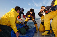
| Here is a picture of the 283cm fish right before it was tagged on Sept. 24th. |
From Jeff Beardsall (who was in the field looking for the tag in Nova Scotia):
My initial reaction to the whole hunt was how cooperative the weather was, and the very nice timing of the whole thing. For about 4 or 5 days prior to the tag releasing the weather had been terrible (rain and wind), so had the tag released earlier we would have had to sit and watch it float out to sea. On top of the weather Dennis had mentioned the boat was out of service for some quick repairs, and the refueling kept him on shore until the moment he left. On his steam up the coast to Pleasant Bay the wind and waves were up and he was thinking that the weather was going to be a huge obstacle in spotting the tag.
Meanwhile I'm tearing across the province in a classic adventure vehicle (1997 Jeep Cherokee) on roads that haven't been resurfaced in about 20 years (my best guess) with urgency after getting off the phone with Steve who had mentioned the tag was taking a line for the Cabot Strait, and once something gets caught in that tide current it moves easterly fast into open ocean. So in my mind it was a race against the currents. At about 4:30pm AST I was climbing a mountain on the west coast of Cape Breton and finally the sun blasted through the days-worth of clouds... a welcome sight to say the least. So I arrive at Pleasant Bay Harbor around 4:55; Dennis had been waiting for about 10 minutes (so not long at all considering the length of the trip), and finished up a casual conversation with another tuna fisherman as I hopped out. we threw the gear on board, and by the time I had the car parked the boat's diesel was chugging away and Dennis was starting to turn the vessel towards the sea. I hopped on the boat and we started the 15nm steam to the last position of the tag. At this point we were well out of cellular signal and our latest tag position was already 30 minutes old.
We turned on the PTT locator about 5nm from our coordinates, and approximately 1nm from our coordinates we heard out first signal. We continued to move ahead and the signal strength continued to rise, and then there was a radical drop in signal. We arrived to the coordinates and found a big mass of wrack (sticks, seaweed, and other types of debris), and we still had signals but the strength suggested the tag was at least 500m in any direction. At this point Dennis explained to me that there are two prevailing currents at that spot... one closer to shore that flowed into the Cabot Strait and out to ocean, and another slightly further offshore that runs northeast up the western shore of Cape Breton but turns west and back into the Gulf of Saint Lawrence. We turned east hoping to catch up to the tag if it had got caught in the eastern current, and much to our pleasure the signal strength dropped quickly. We turned 180 heading back west to the other side of our wrack float... again the signal strength increased up to the wrack and then dropped off to the west of the wrack (another good sign). So we go back to the wrack and bear north and the signals increase. Just about 4 minutes of this and we've hit maximum signal strength so we cut the engine and drift with the seaweeds and jellyfish keeping four watchful eyes on the water. I was looking off port side and Dennis was in the captains seat looking starboard. Dennis called out "THERE IT IS!" and I whipped around. Plain as day we could see the conspicuous "whip" of the tag antennae bobbing about. the surface was about as calm as a backyard pool. I grabbed our dipnet and Dennis maneuvered the boat to the tag as if he had done it a thousand times. We snagged it out of the water on our first pass, gave some congratulatory highfives and hand shakes and turned back to shore.
On our way back we knew the universe was pleased because the sun was big and bright over the water, the highlands were awesome shades of green with shadows casting in the river valleys... Dennis even remarked he hasn't seen a prettier view of Cape Breton. And when we thought the whole excitement was over, we ran into the stars of the show themselves; a couple schools of bluefin tunas. Some big ones, some "small" ones, but they were casually breaking the surface. We imagined they were jumping for joy, but they were probably just warming up in the surface waters. Got to shore and we said ""Well that was almost too easy.. but we'll take it!" I unloaded the gear, and neither of us wasted any time getting back on our respective roads (mine was an actual road, Dennis was taking the watery road) back home. We joked that we thought this tag was going to be the one to ruin our perfect record... because when you have a perfect record you tend get the feeling the next one is going to be the hardest one.
 |
| See if you can see the tag. |
 |
| The tag safe and sound after a long journey! |
 |
| Gulf of Saint Lawrence after a successful mission! |