Monday, February 9, 2009
Tagging North Carolina Giants on Camera
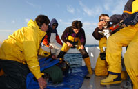
We're pleased to have some beautiful video we shot at TAG NC last month here for viewing pleasure. In this piece we're releasing a large fish that we caught with our excellent angler - aboard long time TAG vessel Sensation. Dale Britt was the Captain and his mate Alan wired this fish on a relatively light leader. This fish was remarkably beautiful on deck at 259 cm curved fork lenth, it was the second largest bluefin ever measured by our team off NC- in over 850 fish tagged. We were at the time a bit surprised by the large size and you may pick that if you listen to our reaction- thats Dr. Andre Boustany at the head end, myself and our mate Alan.
It was so large - we had trouble doing our usual turn - and put the fish out tail first- most go head first. Our team worked very hard the first week of the year- getting some film for teams producing TV shows in 2009-helping to raise awareness about bluefin tuna science- tagging a few fish. We recognized in 2009, once again the challenge we face as a team- tagging giants, when the commercial fishery is wide open. I certainly miss the days when all the fish came our way for tagging. The good news is the footage was awesome and hopefully we can share the story of Carolina bluefin with millions of folks across the globe. I enjoyed tagging and releasing three and wish everyone could feel the exhilaration of seeing a fish up close and personal- and the joy of satellite tagging the animal and letting the fish go.
Thanks to Bill and our colleagues- for this wonderful footage and Dr. Randy Kochevar for his nice edit! Barb
Monday, February 2, 2009
TAG Data Incorporated into new Google Earth
 The TAG team collaborated with Google to create a unique "Animal Tracking" layer in the latest version of Google Earth, which features an interactive, three-dimensional ocean. The most exciting aspect of this is that our tagging data will be made available to a huge audience, in the powerful but user-friendly Google Earth interface.
When users locate a tagged animal on the globe, they can click it to bring up the "content bubble" (on the right in the photo above). There they can learn more about the particular specimen that made the track, as well as seeing the track itself on the globe or following along with it, seeing the ocean from the animal's point of view. They can also learn more about that species in general, and about the type of tag with which the animal was tagged.
The Google Earth interface will play an increasingly important role in our work, as we will begin using it to access and explore tracking data -- from tunas as well as a variety of other open ocean animals being studied by collaborators around the world. This will be the centerpiece of our new Global Tagging of Pelagic Predators website, which launched to the public today.
To learn more about the new Ocean features of Google Earth, go to http://earth.google.com/ocean/, where you can download the latest version and start exploring the oceans in a whole new way!
Subscribe to:
Posts (Atom)